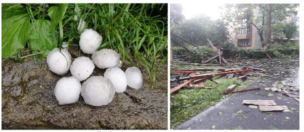
The main purpose of the study is to analyze the conditions and impact of severe weather phenomena in Sălaj and Maramureș counties. A supercell storm that crossed a significant part of the mentioned area in the 28th May 2019’s afternoon, also affecting Zalău and Baia Mare was chosen as a case study through its impact and severe threats that occurred, leaving many damages over the area. The analyzed phenomena are convective, generated by Cumulonimbus clouds with a considerable vertical extent. Synoptic and mesoscale conditions were determined using the specific methods of investigation (charts of sea level pressure, geopotential height, temperature and humidity, atmospheric soundings, different stability indices, vertical wind shear, infrared and visible satellite images and radar images of convective storms). The main findings are: synoptic conditions were determined by low values of atmospheric pressure at the surface and by the atmospheric depressions, while in the middle troposphere, an atmospheric trough was present; mesoscale conditions presented: elevated values of Convective Available Potential Energy, negative values of Lifted Index, and strong wind shear in the 0-3 km layer.
Author: admin

Vegetation fires in Romania: an overview
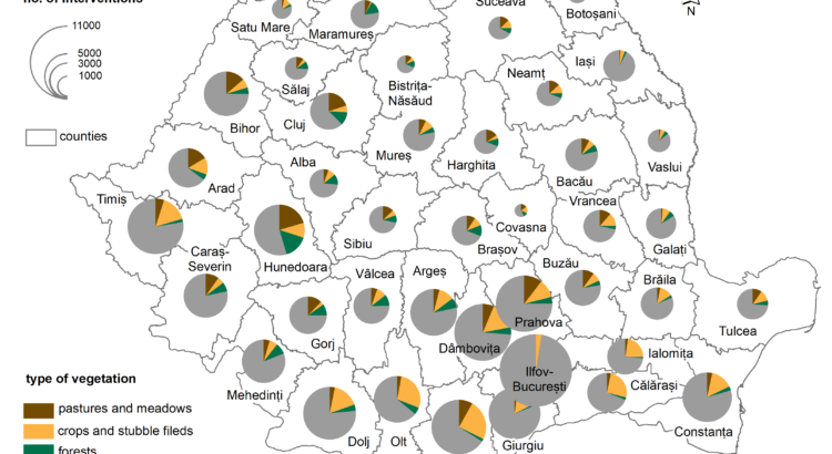
ABSTRACT. – The main purpose of the present paper is to explore the current state of knowledge upon the occurrence and impacts of vegetation fires in Romania and to make a brief report on the sources of data concerning such events, in order to pave the road for further, more detailed studies upon the occurrence of vegetation fires in Romania. Using satellite images-based applications available at EFFIS we could observe that Romania is indeed impacted by many fire events every year. In addition, we worked with a large database provided by the General Inspectorate for Emergency Situations, that includes over 150,000 entries, regarding interventions of fire brigades on vegetation fires in Romania. Among other aspects, these data showed that the main regions for such interventions were the southern and western parts of the country and that the monthly occurrence of such events corresponds to timeframes typical for clearing agricultural lands.
Keywords: vegetation fire, land use, agriculture, impact, Romania.

Assessing soil erosion caused by raindrops utilizing the index of erosion through precipitation (R-factor).
PAULA CODREA, I.H., HOLOBÂCĂ![]() , I.A., IRIMUȘ
, I.A., IRIMUȘ![]() , L. B-BÁLINT
, L. B-BÁLINT
ABSTRACT. Soil erosion caused by raindrops is a topic that arouses the interest of researchers at the international level. The negative impact that this meteorological phenomenon has on the edaphic component determines a limited development of the zone or area on which the entire research process takes place. In order to arrive at an analysis consistent with the reality on the ground, many researchers have used an essential indicator, namely, the R-Factor. It highlights the action of the kinetic energy produced by precipitation over a period of time. The purpose of our research is to reveal the degree of soil erosion following raindrops, with the Someșan Plateau situated in North-West Romania as a study area. The spatio-temporal analysis consisted in the processing of the ESDAC (European Soil Data Centre) databases that were outlined following the application of the R-factor indicator, on which we applied GIS techniques, in order to finally obtain cartographic material that reveals on the basis of several analysis indices, the degree of soil erosion in a time interval (1970-2018). The notable results that we obtained after processing the data, outline the fact that during the analyzed period a low amount of precipitation is recorded, an aspect that creates a low degree of erosion. Regarding the probability of producing erosion determined by this meteorological phenomenon, the values obtained are reduced far below the normal values of the analyzed indicators, highlighting that the probability of producing a high-risk erosion in the near future is zero.The results of our research, including the entire cartographic material, will be able to be used by the competent authorities (the town hall of Bălan commune, the county councilas) as a basis for spatial development projects
Key words: soil erosion, degradation, rain drops, R-factor, indicators, Someșan Plateau, Romania
FULL TEST

The role of the relief in the process of water drainage of the rivers in the Căliman Mountains.
COSTIN HÂRLAV
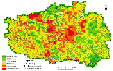
Abstract: The analysis of the flow of river water from a certain surface is very important f r determining the multi-year flow regime. In the formation of the regime, an important role is played by the features of the relief of the hydrographic basin, which directly influence the direction of flow and the speed of the water, and indirectly, the climatic elements. The Căliman Mountains are less analysed from this point of view, the relief elements being included in only a few specialized works. In the study, the role of the morphometric elements (altitude, geodeclivity, density and depth of fragmentation, orientation of the slopes) and morphological elements of the relief in the flow process from the highest volcanic massif in Romania located in the central part of the Eastern Carpathians was analysed.
Keyword: Căliman Mountains, relief, factor, water runoff
FULL TEXT

An Evaluation of Lidar, EU-DEM and SRTM-Derived Terrain Parameters for Hydrologic Applications in Țibleș and Rodnei Mountains (Romania)
ABSTRACT. Over the years numerous geospatial data sets have become accessible to users in the form of various types of digital elevation models (DEMs) at different resolutions. DEMs are often used to study the behavior and hydrological response of watersheds, and so came to be considered as a reflection of their physiographic characteristics. Accurate determination of a catchment’s morphometric parameters plays a crucial role in distributed hydrological modelling and river flow estimation. This study is divided into two parts and objectives; the first part examines the accuracy of DEMs from different sources (EU-DEM, SRTM and LIDAR) in deriving terrain attributes by comparison, and the second one investigates the ability of resampling the 3 m LIDAR DEM to coarser cell resolutions, to accurately represent the extracted hydrological features. In order to evaluate the quality and precision of SRTM and EU-DEM, the high-resolution 3 m LIDAR DEM was used as a reference data set due to its higher degree of accuracy. Firstly, this data set was resampled to 25 m and 30 m to match the EU-DEM and SRTM cell size, and all of them were re-projected in order to have the same Stereo 70 coordinate system for Romania. A comparison has been carried out between the derived hydrologic and terrain variables of the different DEMs. For the second part of this research, LIDAR DEM was also resampled to 10 m and subsequently, another similar evaluation was made, but this time with regards to different cell resolutions (3 m, 10 m, 25 m and 30 m). Several catchments of various drainage areas (Țibleș, Runc, Sălăuța and Valea Caselor) located in Țibleș and Rodnei Mountains were chosen as study areas for this research.
Several resampling techniques available in ArcMap were evaluated, and the comparative analyzes were carried out using the R software. Results revealed not only the LiDAR’s superior accuracy as compared to the other data sets, but also the possibilities offered by the latter for deriving the hydrological characteristics of a mountainous area, contingent upon what the user aims to achieve.
Keywords: Digital elevation models, LIDAR, SRTM, EU-DEM, resample, accuracy, morphometry, R, Rstudio, geospatial analysis
